|
|
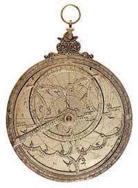
Star-Finding with a PlanisphereBy Alan M. MacRobert The movements of the stars have taxed the human intellect throughout the ages — from ancient Babylonians seeking to predict sky events, to Greek philosophers wrestling with the structure of the universe, to beginning amateurs today trying to point a new telescope at the Andromeda Galaxy. At first, the turning of the celestial sphere perplexes everyone who takes up skywatching. Sooner or later the picture snaps into place and the whole setup becomes obvious. But those who think the sky's motion is inherently simple should try explaining to a beginner why every star follows a different curved path across the sky at a different speed. And why do some stars move from west to east while most move east to west? Can you explain why some constellations turn somersaults during the night while others just tilt from side to side? To bring the sky's motion down to Earth, astronomers for millennia have built little mechanisms that duplicate it. A working model not only illustrates how the sky turns but can help locate objects at any given time. The simplest sky model is a planisphere. Untold numbers of these star finders have been designed and published in the last century. Even the most experienced observers rely on them, especially at unfamiliar hours of the night. The word "planisphere" simply means flat sphere. It incorporates a map of the sky that pivots at the celestial pole. As the map revolves around the pivot, it slides under a mask that represents your horizon. Turning the map mimics the apparent daily motion of the sky, complete with risings and settings at the horizon edges. Ancient OriginsThe basic idea behind the planisphere was used in ancient Rome. The architect and engineer Vitruvius, writing around 27 B.C., described a star map engraved on a solid plate and a horizon mask that rotated over it to show the risings and settings of celestial bodies. A water clock turned the mask once a day to keep up with the sky. Nearly two centuries later, Claudius Ptolemy [astro-tom.com biography link] analyzed the map projections used for such devices in his treatise Planisphaerium.
By the 4th century A.D. a version known as the planispheric astrolabe was in use. Its star map was a skeletal metal framework sliding over a solid plate engraved with the observer's horizon. Medieval Arabs and Persians refined the astrolabe to a peak of versatility and beauty. Some of these rnate "mathematical jewels" made their way to Europe, where they were prized as almost magical. "All the conclusions that have been found, or might be found in so noble an instrument as an astrolabe, are not known perfectly to any mortal man in this region," wrote Geoffrey Chaucer in 1391. By the end of the Middle Ages astrolabes were the universal trademark of astronomers and astrologers. Astrolabes were commonly used to sight on the Sun and stars to tell time. The invention of accurate clocks allowed the procedure to be reversed. If you knew the time, you could use this kind of device to find stars. And that is how planispheres have been employed ever since. Using a PlanisphereIn principle nothing could be simpler. You turn a wheel to put your time next to your date, and presto, there's a custom-made map of the stars that are above your horizon for that moment. The edge of the oval star map represents the horizon all around you, as you would see if you were standing in an open field and turned around in a complete circle. The part of the map at the oval's center represents the sky overhead — much like the all-sky map in Sky & Telescope each month, or the interactive star chart on this site.
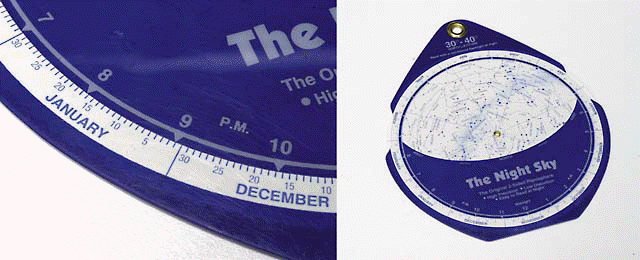
In practice, several complications can throw beginners off. The worst is that a planisphere's map is necessarily small and distorted. It compresses the entire celestial hemisphere above and around you into a little thing you hold in your hand. So star patterns appear much bigger in real life than on the map. Moving your eyes just a little way across the map corresponds to swinging your gaze across a huge sweep of sky. The east and west horizons may look close together on a planisphere, but of course when east is in front of you west is behind your back. Glancing from the map's edge to center corresponds to craning your gaze from horizontal to straight up. There's only one way to get to know a map like this. Hold it out in front of you as you face the horizon. Twist it around so the map edge labeled with the direction you're facing is down. The correct horizon on the map will now appear horizontal and match the horizon in front of you. Now you can compare stars above the horizon on the map with those you're facing in the sky. Then there's the distortion issue. On a planisphere designed for use in the Northern Hemisphere, constellations in the southern part of the sky are stretched sideways, taffy-like, making it hard to compare them with real star patterns. This problem does not exist on a well-designed map for fixed dates and times, such as the one in the center of each month's Sky & Telescope or the interactive star chart on this site. Some planisphere designers have come up with a partial solution. David Chandler's planisphere The Night Sky presents two maps, one on each side. One minimizes distortion north of the celestial equator, the other south of it. Just flip it over for the best view. Fine PointsA further complication is that a planisphere works correctly for only one narrow range of latitudes on Earth. Fortunately, many models (notably Chandler's) are made in several editions, each for a particular latitude range. [Find Your Latitude]
Then there's the matter of daylight saving time. When this is in effect (from the first Sunday in April to the last Sunday in October in most parts of the United States), remember to "fall back" to standard time by subtracting an hour from what your clock says before you set the planisphere's dial. Actually, planispheres don't employ standard time either, but rather local mean time. The difference, which depends on where you live in your time zone, can amount to a half hour or more. The local mean time correction (in minutes) for various U.S. cities is given in the following table. Fortunately, even a half hour one way or the other doesn't really matter for most star finding.
In fact, if you just want to know which constellations are up and where they are, a planisphere's limitations can largely be overlooked. It's remarkable that such a simple working model of the sky can work so well. - - - - - - - - - - - - - - - - - - - - - - - - - - - - - - - - - - - - - - - - - - Alan MacRobert is a senior editor of Sky & Telescope magazine and an avid backyard astronomer.
11/2011 | ||||||||||||||||||||||||||||||||||||||||||||||||||||||||||||||||||||||||||||||||||||||||
|